Wander Lord

Interesting on art, nature, people, history

Category Archive: Countries and cities

Siege of Leningrad. Pages of history

Siege of Leningrad. Pages of history

Siege of Leningrad. Pages of history


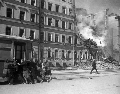
Siege of Leningrad. Pages of history. During World War II German and Finnish armies besieged Leningrad for 872 days. It was the Soviet Union’s second largest city and important center for armaments production. The destruction of Leningrad was one of Adolf Hitler’s strategic objectives in attacking the Soviet Union on June 22, 1941. German Army Group North sealed off Leningrad on September 8, 1941. About 2.5 million people were trapped within the city. During the siege of Leningrad 632 000 people died of hunger, 17 000 Leningraders were killed by bombs and shells, 840 factories and 53.5 million square feet of housing were destroyed.
The only connection that Leningrad maintained with the rest of the Soviet Union was across Lake Ladoga, which German aircraft patrolled.
Hitler’s plan was to subdue Leningrad through blockade, bombardment, and starvation prior to seizing the city. German artillery gunners, together with the Luftwaffe, killed approximately 17,000 Leningraders during the siege.
More »

Liberia – Africa’s Oldest Republic

Liberia - Africa’s Oldest Republic

Liberia – Africa’s Oldest Republic


Liberia is the oldest republic in Africa and its name means “land of the free”. In the 1820s some Americans who opposed slavery bought land in West Africa and used it to create a new country for freed slaves. This country was called Liberia. Its area is 111,370 square kilometers. The official name is Republic of Liberia. To find out about Liberia’s past you can visit the Malima Gorblah Village and Besao Village which preserve the country’s old culture. Liberia borders Sierra Leone, Guinea, and Côte d’Ivoire. The Atlantic Ocean lies to the southwest.
The country’s climate is warm and humid all year and rainy from May to October. Two rare animals are found in Liberia: the pygmy hippopotamus and the manatee. Liberian farmers grow rubber trees, coffee, and cocoa, rice, sugarcane, bananas, and yams.
More »

Guinea – Forests and Minerals

Guinea - Forests and Minerals

Guinea – Forests and Minerals


Guinea is a country in western Africa on the Atlantic Ocean. It borders Guinea-Bissau, Senegal, Mali, Côte d’Ivoire, Liberia, and Sierra Leone. The Fouta Djallon highlands cover much of central Guinea. Many of the major African rivers begin in this area, including the Gambia, the Senegal, the Niger, and 19 others. Guinea has a hot, humid climate with dry winters and wet summers. Its area is 245,857 square kilometers. The official name is Republic of Guinea.
Most people in Guinea work as farmers and grow rice, cassava, sweet potatoes, bananas, coffee, pineapples, peanuts, yams, and corn. Guinea has large amounts of such minerals as bauxite, iron ore, gold, and diamonds. In fact, Guinea is one of the world’s top producers of bauxite, which is used to make aluminum.
More »

Lebanon – small Middle Eastern country

Lebanon - small Middle Eastern country

Lebanon – small Middle Eastern country


Lebanon is a small Middle Eastern country on the eastern coast of the Mediterranean Sea. The official name of the country is Lebanese Republic. It is mostly mountainous. The major mountain range, called the Lebanon Mountains, extends about 161 km northeast to southwest. Qurnat as-Sawda is the highest point (3,088 m). Mt. Hermon, which rises to 2,813 m, is the country’s second-highest peak. The area of the country is 10,400 square kilometers. It borders Israel and Syria. Lebanon has few year-round rivers. Its most important, and longest, river is the Al-Ljtanj (145 km).
Lebanon has a subtropical, temperate Mediterranean climate, with hot, dry summers and cool, humid winters.
Lebanon’s mineral resources include salt, limestone, silica, and gypsum. The mountains are a good source of iron ore. Major crops include potatoes, tomatoes, cucumbers, citrus fruits, onions, grapes, apples, and olives. Goats and sheep are the main livestock.
More »

Greenland – Frozen Island

Greenland - Frozen Island

Greenland – Frozen Island


Greenland is the world’s largest island most of which lies within the Arctic Circle. Its area is 2,175,600 square kilometers. Its northern tip is only 800 kilometers from the North Pole. Mountains run along the island’s east and west coasts. Gunnbjorn is the highest point (3,700 m). Greenland is almost entirely covered in ice and in some places it is more than 3000 meters thick. Deep fjords and glaciers line the coasts; in many areas the great ice sheet runs directly into the sea. The weather in Greenland is cold and may change quickly from sunshine to blizzards.
Greenland’s official name, Kalaallit Nunaat, means “land of the people.”
There are very few trees in Greenland’s tundra. Grasses, sedges, and mosslike lichens are the main plants. Only seven kinds of mammals live there. They are polar bears, musk-oxen, reindeer, arctic foxes, snow hares, ermines, and lemmings.
More »

Colombia – Columbus’ Namesake

Colombia - Columbus’ Namesake

Colombia – Columbus’ Namesake


Colombia, in South America, is the only American nation named for Christopher Columbus. The official name of the country is Republic of Colombia. Colombia is a land of beaches, deserts, jungles, grasslands, and mountains. The Andes range runs the length of the country. Its area is 1,138,910 square kilometers. Colombia shares borders with Venezuela, Brazil, Peru, Ecuador, and Panama.
Colombia lies close to the equator and its climate is generally hot.
Colombia is home to many different kinds of plants and animals. There are more than 130,000 different plants, including a kind of water lily called Victoria amazonica. Its leaves are large and strong enough to support a child. There are more than 1,550 kinds of birds in Colombia.
The country’s most important river is the Magdalena. Pico Cristóbal Colón is the highest point (5,775 m). Amazon is the longest river (6,570 km).
More »

Amazing Abu Simbel Temple

Amazing Abu Simbel temple

Amazing Abu Simbel temple


In the Nubian Desert, which is between the Nile River and the Red Sea, 320 km from the famous Aswan Dam, there is an unusual structure – the majestic Abu Simbel Temple, carved from the mountain ridge, dedicated to the gods Amon-Ra, Harmakhis and Ptah and the deified pharaoh Ramses II. The temple has an amazing history.
In 1813, the Swiss traveler and geographer Johann Burckhardt saw a strange sand-strewn stone boulder on the bank of the Nile. There were four giant sitting figures, which were supposed to depict the gods with the appearance of Pharaoh Ramses II the Great. At the bottom, a narrow stone entrance to the sanctuary was dug out. Soon they found a 65-meter-long passage, the steps of which were decorated with bas-reliefs. In some places there were bright paintings that glorified the military approaches of Ramses II. Thus, the majestic Abu Simbel temple was discovered.
More »